Desert Detours That Define a Vegas Visit: Red Rock Canyon's Trails, Hoover Dam's Might, and Valley of Fire's Flames
16 Apr 2026
Desert Detours That Define a Vegas Visit: Red Rock Canyon's Trails, Hoover Dam's Might, and Valley of Fire's Flames
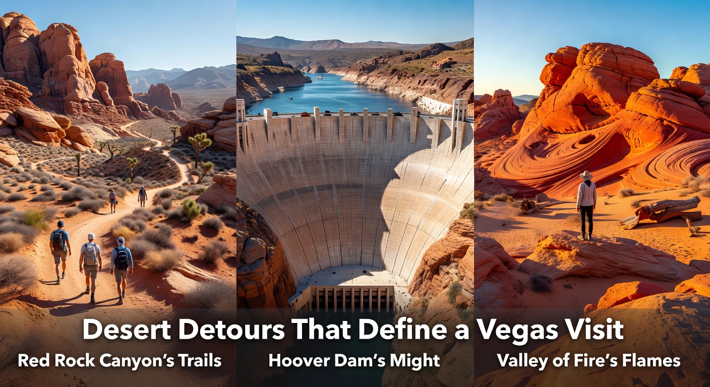
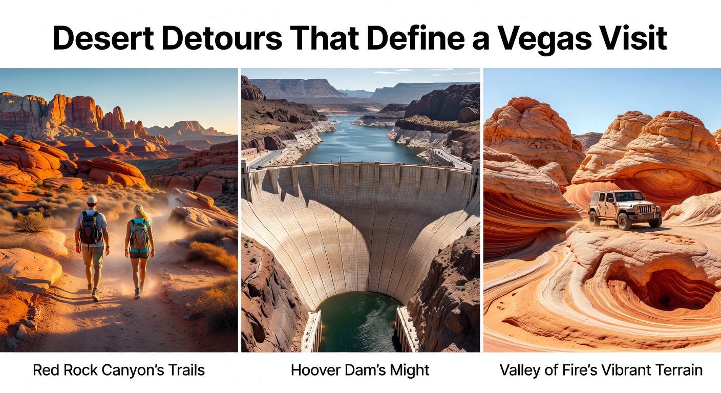
Vegas visitors often chase the neon glow of the Strip, yet those who venture beyond the casinos discover desert landscapes that pack a punch; Red Rock Canyon offers twisting trails through ancient rockscapes, Hoover Dam stands as an engineering marvel harnessing the Colorado River, and Valley of Fire blazes with fiery sandstone waves, all within a short drive from the city, turning a quick getaway into unforgettable detours that showcase Nevada's raw power.
Red Rock Canyon's Trails: Where Mojave Meets Adventure
Just 20 miles west of Las Vegas, Red Rock Canyon National Conservation Area draws over 2 million visitors annually, according to Bureau of Land Management data, its 195,940 acres protecting a slice of the Mojave Desert dotted with Joshua trees and limestone cliffs formed 650 million years ago. Trails here range from easy loops to strenuous climbs, so families stick to the 13-mile Scenic Drive loop while seasoned hikers tackle Calico Tanks, a 2.5-mile path that climbs 450 feet through sandstone basins, revealing panoramic views of the Las Vegas Valley; data from trail logs shows most complete it in under two hours, spotting bighorn sheep along the way.
Take the Turtlehead Peak Trail, for instance, where climbers scramble up 1,000 feet over 1.8 miles, reaching a summit that overlooks Willow Springs and the Keystone Thrust fault, a geological wonder where 550-million-year-old limestone overrides younger sandstone; experts who've mapped the area note how erosion carves these dramatic layers, creating slots perfect for photography. And while summer heat tops 100 degrees Fahrenheit, spring brings wildflowers carpeting the ground—by April 2026, rangers expect peak blooms of desert mariposa lilies after recent wet winters, drawing botanists and photographers in droves.
Visitors often pair a morning hike with picnic spots near Pine Creek, where ancient bristlecone pines cling to rocky slopes, their twisted trunks surviving centuries of harsh winds; one study by University of Nevada researchers found these trees among the oldest in the region, some dating back 1,000 years. That's where the rubber meets the road for Vegas trippers seeking shade and solitude amid the buzz.
Entry costs $15 per vehicle, good for seven days, and a $120 America the Beautiful pass covers it plus other federal sites, making multi-stop itineraries straightforward; crowds peak weekends, so early starts around 6 a.m. beat the rush, especially as shuttle services expand in 2026 to cut traffic on the popular loop road.
Hoover Dam's Might: Power and Precision on the Colorado
About 30 miles southeast of Vegas, Hoover Dam rises 726 feet high and stretches 1,244 feet across Black Canyon, its 3.25 million cubic yards of concrete poured between 1931 and 1935 generating enough hydroelectric power for 1.3 million people today, figures from the U.S. Bureau of Reclamation confirm. Engineers designed the arch-gravity structure to withstand earthquakes up to 8.0 magnitude, diverting the Colorado River to form Lake Mead, now the largest U.S. reservoir by volume when full at 28.5 million acre-feet.
Tours reveal the dam's innards: the powerplant houses 17 massive turbines producing 2,080 megawatts, while the bypass bridge—opened in 2010—offers vertigo-inducing walks 900 feet above the river; observers note how Mike O'Callaghan–Pat Tillman Memorial Bridge traffic logs show 2 million vehicles yearly, easing old highway bottlenecks. And here's where it gets interesting: drought has dropped Lake Mead levels to 35% capacity recently, prompting water conservation talks, yet the dam's output remains steady thanks to upgraded generators.
Day trippers access free exterior views from the Nevada side, but $10 powerplant tours or $30 hardhat versions descend 500 feet via elevators into turbine galleries humming with energy; families favor the exhibit hall with vintage construction photos and a 1930s movie theater. By April 2026, spring maintenance wraps up, aligning visitor hours from 9 a.m. to 5 p.m. daily, coinciding with wild turkey sightings in nearby canyons.
Proximity to Vegas means easy combos—hike Red Rock morning, dam afternoon—since drive times total under 90 minutes round-trip; parking fills fast, so carpools or tour buses from the Strip handle the logistics seamlessly.

Valley of Fire's Flames: Ancient Rocks Ignited by Sun
Northeast of Vegas by 50 miles, Valley of Fire State Park spans 402 miles of Aztec sandstone swirled in reds, pinks, and whites, aztec formations dating 150 million years to the Jurassic period when dinosaurs roamed, per geological surveys from Nevada state geologists. Named for sun-baked hues that shift dramatically at dawn or dusk, the park logs 400,000 visitors yearly, its petroglyphs—over 2,000 panels etched by Basketmaker culture 4,000 years ago—adorning Atlatl Rock and showcasing bighorn sheep hunts.
Fire Wave trail steals the show, a 1.5-mile easy loop undulating like ocean waves through 150-million-year-old cross-bedded sandstone; hikers finish in 45 minutes, often pausing for ripple marks fossilized in stone. Mouse's Tank trail, meanwhile, follows a dry wash 0.75 miles to a natural basin holding rainwater, lined with 1,200-year-old Barrier Canyon-style pictographs; data indicates summer monsoons fill it sporadically, attracting wildlife like kit foxes.
Campers claim 72 sites with hookups for $25 nightly, while day use runs $10 per vehicle; road conditions suit sedans, although White Domes loop's washboard gravel demands caution after rains. What's notable is how April 2026 forecasts mild temps in the 70s Fahrenheit, ideal for White Gold Wheelchair Trail—a accessible 1-mile path through slot canyons—or the Arch Rock detour, where natural bridges frame the desert expanse.
Those who've explored all three spots often loop them in a full day: Red Rock at dawn, Hoover Dam midday, Valley of Fire at sunset, covering 200 miles with stops for gas in Boulder City; apps like AllTrails log user routes, confirming feasibility under six hours driving.
Tying It Together: Logistics and Seasonal Tips
These detours fit Vegas itineraries like a glove, with rental cars from McCarran Airport averaging $50 daily; gas stations dot US-93 and NV-159, and apps track real-time traffic avoiding construction. Spring 2026 brings events like Valley of Fire's annual astronomy night on April 18, stargazing under moonless skies unpolluted by city lights, while Red Rock hosts guided geology walks April 12-14.
Hydration rules supreme—rangers report 20 heat-related rescues yearly—so packs carry 1 gallon water per hour hiking; sunscreen and hats counter UV indexes hitting 10. Permits needed? None for day use, but backcountry at Red Rock requires free tags; Valley of Fire weddings book arches months ahead.
Combine with Lake Mead boating, where marinas rent houseboats from $1,000 daily, accessing hidden coves near the dam; fishing yields striped bass peaking April-May, per Nevada Department of Wildlife stats.
Wrapping the Desert Loop
Red Rock's trails build endurance, Hoover Dam's scale inspires awe, Valley of Fire's colors mesmerize—together they transform Vegas trips from slots-and-shows to epic escapes rooted in nature's extremes; over 5 million explore these sites yearly, data shows sustained growth post-pandemic. Plan ahead via state park reservations opening January 2026, and those detours become the highlights that linger long after the flight home.